


Preview
Identifier
20086241
Description
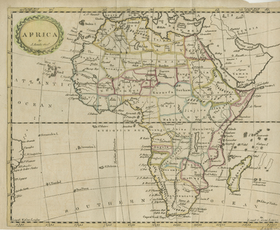
This map of Africa is from a 1796 edition of Scottish history. It shows a continent divided into many different regions (by color) but with almost no interior detail. Some land forms depicted throughout continent. What is provided is almost inevitably wrong including the east to west course of the Niger River and "Lake Maravi.' There is a simply decorated and colored wreath at the top right in the Atlantic Ocean. Horizontal, single paged, single sided map with two folds (as issued). Original outline has hand coloring and is in good condition with narrow or absent blank margins (as issued). 18 cm. x 20 cm. [Gift of Dr. Jack Franke]
Archival Date
1796
Collection Name
Maps of Africa
Collection Number
Acc. 2019-329
Language
English
Original Format
Maps
File Format
JPG
Rights
Rights held by The University of Texas at Arlington Libraries, Special Collections. Any use of content downloaded or printed from this page is limited to non-commercial personal or educational use, including fair use as directed by U.S. copyright laws. For more information or for reproduction requests, please contact UTA Special Collections by emailing spcoref@uta.edu.
License

This work is licensed under a Creative Commons Attribution-NonCommercial 4.0 International License
Subjects
Maps; Africa; Islands; Rivers; Lakes