


Preview
Identifier
20086339
Description
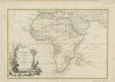
Uncolored map of Africa from Jean Lattre's "Atlas Moderne" published in Bordeaux. Includes Madagascar, neighboring regions of Persia and Arabia (in detail), and the southern Mediterranean (generally). African regions are divided by color-coded outlines that correspond to European colonial holdings. Map key not provided for colonial holdings and region(s). The course of the Nile follows the "Ptolemaic two lake theory" with its source being the fictitious Mountains of the Moon, south of the Ptolemaic lakes. Much of central Africa is blank, suggesting profound lack of knowledge on continent's interior. Several major river systems, including the Niger, the Congo, and parts of the Nile show indications of active exploration. Names and locale of African kingdoms and tribal groups located, though few correspond with groups known today. Decorative title cartouche located in bottom left featuring a Nile crocodile, leopard, surrounding vegetation, and a bird. Landforms and waterways generally depicted throughout. Border surrounding map includes scale. Scale key not provided. Hachures depicted off coast(s). Map was drawn by J. Janvier for issue, as plate no. 23 in Jean Lattre's 1775 issue of the "Atlas Moderne." Double-paged, single-sided, horizontal map. 30 cm. x 43 cm. [Gift of Dr. Jack Franke]
Archival Date
1767
Collection Name
Maps of Africa
Collection Number
Acc. 2019-192
Language
French
Original Format
Maps
File Format
JPG
Rights
Rights held by The University of Texas at Arlington Libraries, Special Collections. Any use of content downloaded or printed from this page is limited to non-commercial personal or educational use, including fair use as directed by U.S. copyright laws. For more information or for reproduction requests, please contact UTA Special Collections by emailing spcoref@uta.edu.
License

This work is licensed under a Creative Commons Attribution-NonCommercial 4.0 International License
Subjects
Maps; Africa; Colonies; Deserts; Lakes; Rivers; Mountains; Oceans; Cartouches (Graphic); Congo (Democratic Republic)