


Preview
Identifier
20086240
Description
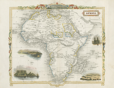
Colored map of Africa with five vignettes depicted around continent; featuring St. Helena, Cape of Good Hope, Statues of Memnon in Egypt, Cataracts of the Nile, and Pyramids of Giza. Title is located at top right. The map is reminiscent of the style of John Tallis. Decorative border is included around map, featuring two indigenous peoples parallel to one another (on left and right side). Vignette featuring The Pyramids of Giza are located at top center of decorative border. Single-paged, single-sided, horizontal map folded at centrefold. 25 cm. x 30 cm. [Gift of Dr. Jack Franke]
Archival Date
1850
Collection Name
Maps of Africa
Collection Number
Acc. 2019-383
Language
English
Original Format
Maps
File Format
JPG
Rights
Rights held by The University of Texas at Arlington Libraries, Special Collections. Any use of content downloaded or printed from this page is limited to non-commercial personal or educational use, including fair use as directed by U.S. copyright laws. For more information or for reproduction requests, please contact UTA Special Collections by emailing spcoref@uta.edu.
License

This work is licensed under a Creative Commons Attribution-NonCommercial 4.0 International License
Subjects
Maps; Vignettes; Africa; Islands; Rivers; Lakes; Illustrations