


Alternative Title
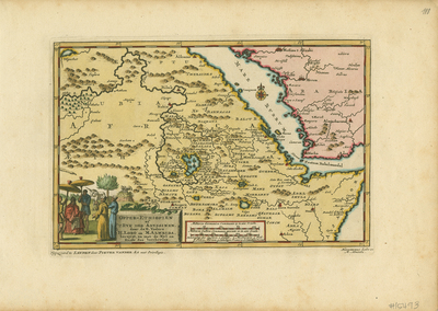
[Upper Ethiopia or the Kingdom of Abyssinia travelled by the blessed Fathers H. Lobo and M. Almeida, described along with the Nile and the Red Sea]
Preview
Identifier
20086460
Description
Detailed map of part of east Africa showing the southern part of the Red Sea, the horn of Africa based upon the map of Ethiopia by Portuguese Jesuit missionaries Jeronimo Lobo and Manuel de Almeida. The pictorial scene in lower left corner depicts these two missionaries meeting the king of Abyssinia, thought to be related to the quasi-mythical Christian King Prester John. There is a white unicorn and a pelican in the background. Both of these were roughly based upon descriptions of animals in Father Lobo's journal. The reference to a unicorn would puzzle Europeans for years. From "Gedenk-waardige Aanteekeningen, Gehouden door de Eerwaarden Vader Hieronymus Lobo, ob syn Voyagie, Gedaan in het Jaar, 1636..." published in Leiden by Pieter van der Aa in 1706. Colored, horizontal map, single-paged and single-sided. 15 cm. x 24 cm. [Gift of Dr. Franke]
Archival Date
1706
Collection Name
Maps of Africa
Collection Number
Acc. 2019-203
Language
Dutch
Original Format
Maps
File Format
JPG
Rights
Rights held by The University of Texas at Arlington Libraries, Special Collections. Any use of content downloaded or printed from this page is limited to non-commercial personal or educational use, including fair use as directed by U.S. copyright laws. For more information or for reproduction requests, please contact UTA Special Collections by emailing spcoref@uta.edu.
License

This work is licensed under a Creative Commons Attribution-NonCommercial 4.0 International License
Subjects
Maps; Africa; Red Sea; Ethiopia; Eritrea; Sudan; Jesuit missionaries; Illustrations; Unicorns; Pelicans; Nile; Rivers; Mountains; Cartouches (Graphic)