


Preview
Identifier
20086311
Description
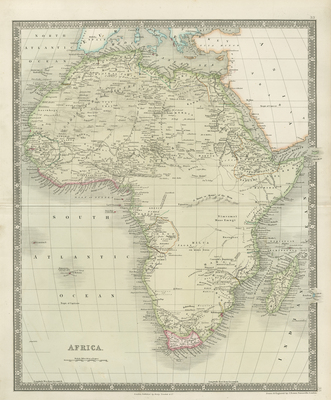
Uncolored map of Africa, with original hand colored outlines, engraved by John Dower and published by Henry Teesdale & Co. of London, ca. 1844. Hachures depicted along coastline(s) of continent and surrounding islands. Color used to distinguish coastal regions. Mountain ranges and landforms located within map, including Mountains of the Moon. Surrounding regions of Arabia and parts of Mediterranean included in map. Title and scale located in bottom left. Border around map includes scale and without decoration. This map provides a historical perspective of cultural and physical landscapes during this time period. The wide range of information provided on this map makes it useful in the study of historic geography. Double paged, single sided, vertical map. 47 cm. x 38 cm. [Gift of Dr. Jack Franke]
Archival Date
1844
Collection Name
Maps of Africa
Collection Number
Acc. 2019-327
Language
English
Original Format
Maps
File Format
JPG
Rights
Rights held by The University of Texas at Arlington Libraries, Special Collections. Any use of content downloaded or printed from this page is limited to non-commercial personal or educational use, including fair use as directed by U.S. copyright laws. For more information or for reproduction requests, please contact UTA Special Collections by emailing spcoref@uta.edu.
License

This work is licensed under a Creative Commons Attribution-NonCommercial 4.0 International License
Subjects
Maps; Africa; Oceans; Mountains; Historical geography