


Preview
Identifier
20086310
Description
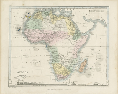
Original, hand colored map of Africa published in "A School Atlas Of Modern Geography Containing Forty Maps, Prepared from the Best Authorities and Including the Latest Discoveries With a Copious Index." Scale and title of map located in bottom left. Beneath includes illustration of various elevations within different mountain ranges and terrains of continent. Landforms depicted, with stippling used to indicate desert regions. Top right includes table of inhabitant population, numbers ranging from 100,000 to below 10,000 inhabitants, with respective areas depicted throughout map. Regions within continent distinguished by color. Hachures included along coast(s) and nearby islands. This map was largely used in public and private schools. Drawn and engraved by John Dower, Pentonville, London, and published by Orr & Company, Amen Corner, Paternoster Row. Publisher information located in bottom margin. Border of map includes scale. Single sided, single paged, horizontal map. 21 cm. x 26 cm. [Gift of Dr. Jack Franke]
Archival Date
1849
Collection Name
Maps of Africa
Collection Number
Acc. 2019-335
Language
English
Original Format
Maps
File Format
JPG
Rights
Rights held by The University of Texas at Arlington Libraries, Special Collections. Any use of content downloaded or printed from this page is limited to non-commercial personal or educational use, including fair use as directed by U.S. copyright laws. For more information or for reproduction requests, please contact UTA Special Collections by emailing spcoref@uta.edu.
License

This work is licensed under a Creative Commons Attribution-NonCommercial 4.0 International License
Subjects
Maps; Africa; Oceans; Islands; Cartouches (Graphic); Population