


Preview
Identifier
20086258
Description
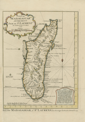
Engraved by Van Schley, uncommon, colored Dutch edition of Bellin's map of Madagascar. Features topography of mountains, rivers, sandbars, and harbors in detail. Note from cartographer, at bottom right corner explains southeastern portion of the island, between the Antavare and Mandreray Rivers; requires level of detail that could not be included on this map, but is available on a map by Sr. de Flecourt published in 1656. Decorative, floral, title cartouche located in top left corner. Alternate Dutch title located outside of map's border as: "Eiland Madagaskar, of St. Laurens, door N.B., Ingen.r des Franssen Zeevaards, 1747." A fleur-de-lis motif depicted to the right of Madagascar. Border surrounding map includes scale. Scale key provided within title cartouche. Hachures depicted off coast(s). Single-paged, single-sided, vertical map on laid paper. 29 cm. x 22 cm. [Gift of Dr. Jack Franke]
Archival Date
1747
Collection Name
Maps of Africa
Collection Number
Acc. 2019-280
Language
French;Dutch
Original Format
Maps
File Format
JPG
Rights
Rights held by The University of Texas at Arlington Libraries, Special Collections. Any use of content downloaded or printed from this page is limited to non-commercial personal or educational use, including fair use as directed by U.S. copyright laws. For more information or for reproduction requests, please contact UTA Special Collections by emailing spcoref@uta.edu.
License

This work is licensed under a Creative Commons Attribution-NonCommercial 4.0 International License
Subjects
Maps; Africa; Islands; Oceans; Cartouches (Graphic); Mountains; Rivers