


Preview
Identifier
20086448
Description
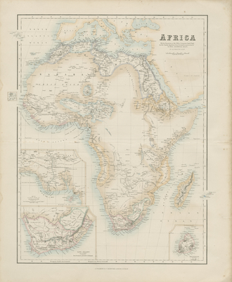
Detailed double map by G. H. Swanston, with insert maps of Mauritius, Cape Colony, and Delta of the Niger published by Archibald Fullarton with his 'Royal Illustrated Atlas,' Edinburgh circa 1874. Map shows the extent of European discoveries and geographical knowledge in the middle of the 19th century. Fullarton's 'Royal Illustrated Atlas,' the last highly decorative atlas published in England. Even the maps without views or figures are beautifully engraved and colored with a mixture of printed color and hand color. Swanston, Petermann, Bartholomew, Macnab and Johnson engraved the maps. The maps bear a superficial resemblance to Keith Johnston's Royal Atlas. Fullarton frequently gives the sources for his maps - for the United States maps he gives Calvin Smith and Tanner as sources. 52 cm. x 41 cm. [Gift of Dr. Jack Franke]
Archival Date
1874
Collection Name
Maps of Africa
Collection Number
Acc. 2019-198
Language
English
Original Format
Maps
File Format
JPG
Rights
Rights held by The University of Texas at Arlington Libraries, Special Collections. Any use of content downloaded or printed from this page is limited to non-commercial personal or educational use, including fair use as directed by U.S. copyright laws. For more information or for reproduction requests, please contact UTA Special Collections by emailing spcoref@uta.edu.
License

This work is licensed under a Creative Commons Attribution-NonCommercial 4.0 International License
Names
Royal Geographical Society
Subjects
Maps; Africa; Royal Geographical Society (Great Britain)