


Preview
Identifier
20086427
Description
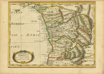
Detailed map of Gabon, the Congo and Angola from Cape Lopez and Sao Tomé to approximately the border with present-day Namibia. The map depicts mountains, rivers, forests and trails and includes a whimsical baroque title cartouche in the lower left corner. Engraved by Antoine de Winter, the map here appeared in a work published by Francois Halma titled "Algemeene Weereld-Beschryving..." which was a 1705 Dutch edition of A. Phérotée de la Croix's "Nouvelle Methode Pour Apprendre Facilement la Geographie Universelle," first published in 1690. Colored, horizontal map. Double paged, single sided map with binding on verso centrefold. 20 cm. x 26 cm. [Gift of Dr. Jack Franke]
Archival Date
1705
Collection Name
Maps of Africa
Collection Number
Acc. 2019-276
Language
Dutch;French
Original Format
Maps
File Format
JPG
Rights
Rights held by The University of Texas at Arlington Libraries, Special Collections. Any use of content downloaded or printed from this page is limited to non-commercial personal or educational use, including fair use as directed by U.S. copyright laws. For more information or for reproduction requests, please contact UTA Special Collections by emailing spcoref@uta.edu.
License

This work is licensed under a Creative Commons Attribution-NonCommercial 4.0 International License
Subjects
Maps; Africa; Mountains; Waterways; Forests; Trails & paths; Cartouches (Graphic)