


Alternative Title
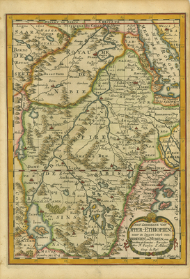
[The Portion of Upper Ethiopia. Wherein Lie the Kingdoms of Abissinia and Nubia, etc. Drawn from Sanuto and Mercator]
Preview
Identifier
20086422
Description
This Dutch-language map contains focuses on the rumored Ptolemaic twin lakes of Zaire and Zaflan that were purported to be the source of the Nile, located at the foot of the mythical "Lunae Montes," or Mountains of the Moon, often identified as the Ruwenzori Mountains in Uganda. The map is filled with fictitious place names and topography, all meticulously detailed. It was engraved by Antoine de Winter from a map by the French cartographer Nicolas Sanson. This map appeared in "Algemeene Weereld-Beschryving..." (The Complete World Described...), a 1705 Dutch edition published by Francois Halma of A. Phérotée de la Croix's "Nouvelle Methode Pour Apprendre Facilement la Geographie Universelle," which first appeared in 1690. Colored, horizontal map. Double-paged, single-sided map folded at center. 29 cm. x 21 cm. [Gift of Dr. Jack Franke]
Archival Date
1705
Collection Name
Maps of Africa
Collection Number
Acc. 2019-273
Language
Dutch
Original Format
Maps
File Format
JPG
Rights
Rights held by The University of Texas at Arlington Libraries, Special Collections. Any use of content downloaded or printed from this page is limited to non-commercial personal or educational use, including fair use as directed by U.S. copyright laws. For more information or for reproduction requests, please contact UTA Special Collections by emailing spcoref@uta.edu.
License

This work is licensed under a Creative Commons Attribution-NonCommercial 4.0 International License
Subjects
Maps; Africa; Uganda; Ethiopia; Eritrea; Kenya; Sudan; Tanzania; Djibouti; Mountains; Rivers; Lakes; Cartouches (Graphic)