


Preview
Identifier
20086418
Description
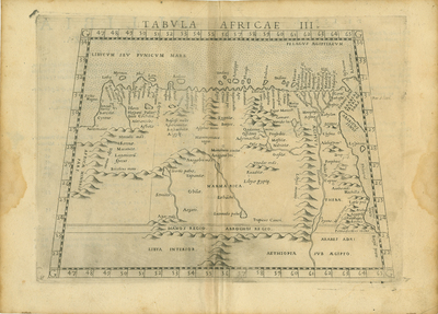
1574 edition of Girolamo Ruscelli's 1561 map of a part of North Africa and the Mediterranean, stretching from Egypt and the Red Sea or "Arabicus Sinus" in the east to eastern Libya and the Gulf of Sidra or "Sirtis Magna" in the west. It was based upon the writings or "Geographia" of the second-century Greek geographer Claudius Ptolemy. Ruscelli's work was essentially an enlarged version of fellow Venetian Giacomo Gastaldi's 1548 edition of Ptolemy's geography, noted as one of the first works to feature maps printed from copper plates. Horizontal map. Italian text "Di Libia" on verso. Double paged, double sided with centerfold binding on one side. Full image on one side and text with numerical information on reverse. 22 cm. x 29 cm. [Gift of Dr. Jack Franke]
Archival Date
1574
Collection Name
Maps of Africa
Collection Number
Acc. 2019-222
Language
Italian;Latin
Original Format
Maps
File Format
JPG
Rights
Rights held by The University of Texas at Arlington Libraries, Special Collections. Any use of content downloaded or printed from this page is limited to non-commercial personal or educational use, including fair use as directed by U.S. copyright laws. For more information or for reproduction requests, please contact UTA Special Collections by emailing spcoref@uta.edu.
License

This work is licensed under a Creative Commons Attribution-NonCommercial 4.0 International License
Subjects
Maps; Africa; Egypt; Rivers; Libya; Red Sea; Seas; Mediterranean Sea; Engravings