


Alternative Title
Marmarica Nuova Tavola
Preview
Identifier
20086417
Description
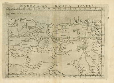
Venetian Girolamo Ruscelli's "new" map of eastern North Africa, an update of the standard maps based upon the writings of second-century Greek geographer, Claudius Ptolemy. From Ruscelli's 1574 edition of Ptolemy's "Geographia." This portion is centered on the Nubian Desert, showing Egypt, the Nile, and the area of present Libya west to Cyrenaica. Ancient Marmarica was a littoral area between Cyrenaica, Aegyptus, and into ancient Libya. By this time the area was loosely under the control of the Ottoman Empire, which had expanded in the 15th and 16th centuries under a line of committed and effective Sultans. Ruscelli first published his map in 1561 during the reign of Suleiman The Magnificent, most associated with the Golden Age and maximum expansion of the Ottoman Empire into Africa, Europe, and the Mediterranean. Horizontal uncolored copper-plate engraved map. Double sided, single page with centrefold. Verso has Italian text. 22 cm. x 29 cm. [Gift of Dr. Jack Franke]
Archival Date
1574
Collection Name
Maps of Africa
Collection Number
Acc. 2019-219
Language
Latin
Original Format
Maps
File Format
JPG
Rights
Rights held by The University of Texas at Arlington Libraries, Special Collections. Any use of content downloaded or printed from this page is limited to non-commercial personal or educational use, including fair use as directed by U.S. copyright laws. For more information or for reproduction requests, please contact UTA Special Collections by emailing spcoref@uta.edu.
License

This work is licensed under a Creative Commons Attribution-NonCommercial 4.0 International License
Subjects
Maps; Africa; Egypt; Rivers; Deserts; Nubia; Libya; Engravings