


Preview
Identifier
20086403
Description
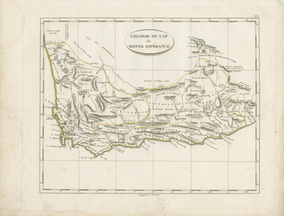
Early 19th century uncolored map of Cape of Good Hope under colonial rule. Map border includes scale. Region outlined in yellow. No key provided. Hachures seen off coast. Title located at center with hachures underneath. Landforms, waterways, and some tribes noted within region. Single-paged, single-sided, horizontal map. 20 cm. x 25 cm. [Gift of Dr. Jack Franke]
Archival Date
1804
Collection Name
Maps of Africa
Collection Number
Acc. 2019-363
Language
French
Original Format
Maps
File Format
JPG
Rights
Rights held by The University of Texas at Arlington Libraries, Special Collections. Any use of content downloaded or printed from this page is limited to non-commercial personal or educational use, including fair use as directed by U.S. copyright laws. For more information or for reproduction requests, please contact UTA Special Collections by emailing spcoref@uta.edu.
License

This work is licensed under a Creative Commons Attribution-NonCommercial 4.0 International License
Subjects
Maps; Africa; Cape of Good Hope (Colony); Colonies; Coastlines