


Preview
Identifier
20086399
Description
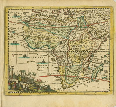
Engraved miniature map from Jacques Peeters' "l'Atlas en abrégé, ou nouvelle description du monde...," published in Antwerp in 1692. Hand-colored continental map of Africa with a scene at lower right by "Karrewyn" depicting merchants in Muslim costume and other indigenous peoples engaged in trade, together with Roman columns and pyramids. European ships range along the west coast. References to the Equator, Tropics of Cancer, and Capricorn (red lines) are included. Map is single paged, single sided. 15 cm. x 18 cm. [Gift of Dr. Franke]
Archival Date
1692
Collection Name
Maps of Africa
Collection Number
Acc. 2019-298
Language
French
Original Format
Maps
File Format
JPG
Rights
Rights held by The University of Texas at Arlington Libraries, Special Collections. Any use of content downloaded or printed from this page is limited to non-commercial personal or educational use, including fair use as directed by U.S. copyright laws. For more information or for reproduction requests, please contact UTA Special Collections by emailing spcoref@uta.edu.
License

This work is licensed under a Creative Commons Attribution-NonCommercial 4.0 International License
Subjects
Maps; Africa; Rivers; Mountains; Cartouches (Graphic); Miniature works; Illustrations; Commerce; Merchants