


Preview
Identifier
20086244
Description
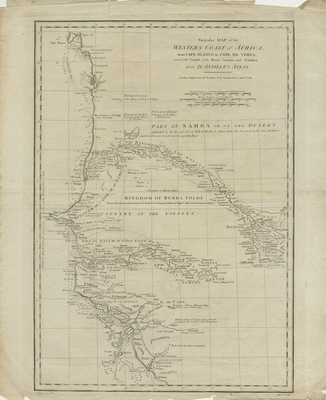
Copper engraved, uncolored map of western coast of Africa, by John Harrison, London, for "The History of England..." by Rapin de Thoyras. Title located at top right, with publisher information and scale key (three different measurements provided) below. Surrounding border of map includes scale. Various tribal regions/kingdoms noted with minimal context. Soundings, water depth measurements, and hachures included along coast(s) and shoreline(s). Terrain, landforms, and waterways located throughout. Double-paged, single-sided, vertical map with original centrefold and binding on verso. 52 cm. x 44 cm. [Gift of Dr. Jack Franke]
Archival Date
1788
Collection Name
Maps of Africa
Collection Number
Acc. 2019-388
Language
English
Original Format
Maps
File Format
JPG
Rights
Rights held by The University of Texas at Arlington Libraries, Special Collections. Any use of content downloaded or printed from this page is limited to non-commercial personal or educational use, including fair use as directed by U.S. copyright laws. For more information or for reproduction requests, please contact UTA Special Collections by emailing spcoref@uta.edu.
License

This work is licensed under a Creative Commons Attribution-NonCommercial 4.0 International License
Subjects
Maps; Africa; Islands; Rivers; Engravings; Capes (Coasts); Waterways