


Preview
Identifier
20086376
Description
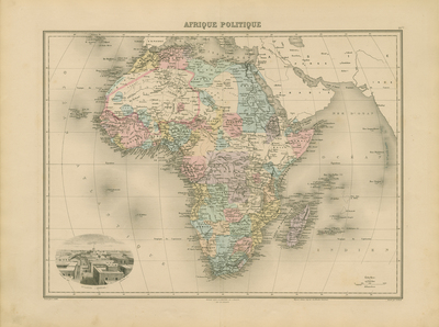
Relief shown by hachures. Latitudinal and longitudinal lines. Coordinates approximate and based on Greenwich meridian. Bar scale on map given in "kilomètres." Shows topography, drainage, vegetation (deserts), colonial possessions, islands surrounding continent. Features tribal territories. "50 bis" at top right margin. Pictorial vignette: St. Louis (Sénégal)/ Fillatreau del. Barbier sc. Double page, bound on backside. 40 cm. x 53 cm. Accompanied by two pages of French text. [Gift of Dr. Jack Franke]
Archival Date
1880
Collection Name
Maps of Africa
Collection Number
Acc. 2019-265
Language
French
Original Format
Maps
File Format
JPG
Rights
Rights held by The University of Texas at Arlington Libraries, Special Collections. Any use of content downloaded or printed from this page is limited to non-commercial personal or educational use, including fair use as directed by U.S. copyright laws. For more information or for reproduction requests, please contact UTA Special Collections by emailing spcoref@uta.edu.
License

This work is licensed under a Creative Commons Attribution-NonCommercial 4.0 International License
Subjects
Maps; Africa; Deserts; Rivers; Mountains; Islands; Colonies; Vignettes