


Preview
Identifier
metapth231510
Description
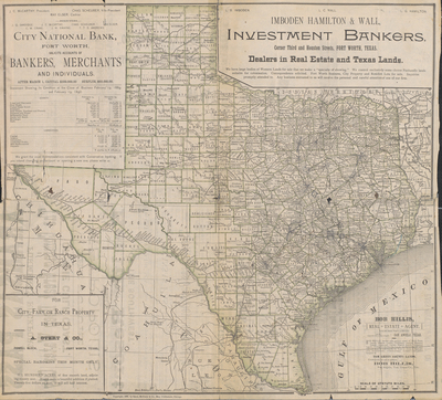
This 1889 map of Texas is on the reverse side of a promotional broadside that sings the praises of “Aransas Pass, Formerly Rockport. The Coming Great Deep Water City of the Gulf Coast.” Since the early 1800s, promoters have used maps to draw attention to business ventures of one type or another. This particular one encourages settlement and the purchase of land in Aransas Pass, which is on the Gulf of Mexico across Redfish Bay from Port Aransas in Aransas, San Patricio, and Nueces counties. The town was named for the pass between Mustang and St. Joseph’s islands on the Gulf Coast, a pass being a break in an island through which vessels can enter the water on the other side of that island. In the period after the Civil War, many developers were northerners who had capital to invest in Texas. The town’s early developers hoped wanted to found a great deepwater port in the city on the Gulf, and they worked for much of the latter half of the 1800s to do this. Russell B. Harrison, the son of U.S. President William Henry Harrison, was one of the organizers of this effort. The date of the map is significant because it was produced at the height of the promotional efforts. Unfortunately for the developers and promoters, however, the Panic of 1893 that shook the U.S. economy also undermined their efforts for a while. It was not until 1907 that a deepwater channel was completed at Aransas Pass. In many ways, the promotional texts and advertisements surrounding the map and on the other side of it are as important as the map itself. They reveal clearly that the map is essentially a business tool aimed at attracting attention to the Gulf Coast and to stimulate the business of the banks, real estate agents, and merchants advertising on the map. The map itself, an 1889 Rand McNally creation, is a rather ordinary map of Texas showing county, town, and railroad development. At the time, the Rand McNally Company was the largest producer of maps in the U.S., and the company’s maps were used in promotional products across the country.
Archival Date
1889
Location
129/3
Collection Name
Cartographic Connections
Collection Number
00769
Publisher
University of Texas at Arlington Libraries
Original Format
Map
File Format
JPG
Rights
Any use of content downloaded or printed from this site is limited to non-commercial personal or educational use, including fair use as directed by U.S. copyright laws. For more information or for reproduction requests, please contact Special Collections
Subjects
Texas
Item Type
image
Names
Rand McNally & Co.
Subjects
Texas