


Preview
Identifier
metapth190446
Description
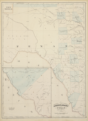
New York atlas publishers Asher & Adams’ map of the western portion of Texas shows minimal topographical features along with western counties established before 1871, when an enormous Pecos County was created from El Paso and Presidio Counties. The projected route of the Texas & Pacific Railway crosses the plain from east to west, continuing into the inset of far western Texas at lower left. Construction on this railroad had halted in Dallas due to the financial panic of 1873 and it did not resume until 1876, when a small section was extended to nearby Fort Worth. Further work on the western portion of the railroad shown in this map did not resume until 1880.
Archival Date
1874
Location
62/5
Collection Name
Cartographic Connections
Collection Number
2005-467
Publisher
University of Texas at Arlington Libraries
Original Format
Map
File Format
JPG
Rights
Any use of content downloaded or printed from this site is limited to non-commercial personal or educational use, including fair use as directed by U.S. copyright laws. For more information or for reproduction requests, please contact Special Collections
Subjects
Texas
Item Type
image
Names
Asher & Adams
Subjects
Texas