


Preview
Identifier
metapth298324
Description
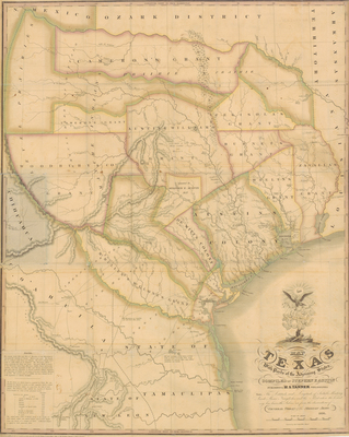
Stephen F. Austin, a Texas empresario, pledged to compile a map of the Province of Texas as part of the agreement for his colonization grant in 1823. He spent six years observing the region and gathering information from travelers and surveyors. In 1828 Austin made arrangements to have the map printed and distributed by the prominent Philadelphia publisher, Henry S. Tanner. In 1829 Austin forwarded his final manuscript draft to Tanner who issued it in March of 1830. Austin, when forwarding the map to the Mexican government, wrote that his reasons for compiling the map were for the benefit of Mexico. However, in letters to this lawyer, Austin claimed he wanted to “bring this country into the public view”, and that some quiet promotion was necessary to defeat the Mexican restrictions on Anglo immigration and to insure the success of the colonies. The successful map was updated and re-issued four times during the next ten years. The 1836 edition is the map included on the Cartographic Connections site. Austin’s maps provided the most accurate depiction of the region at the time. The map was accepted as the authority for the area and copied many times by other cartographers and publishers. [Gift of Virgina Garrett]
Archival Date
1830
Location
90/1
Collection Name
Cartographic Connections
Collection Number
00693
Publisher
University of Texas at Arlington Libraries
Original Format
Map
File Format
JPG
Rights
Any use of content downloaded or printed from this site is limited to non-commercial personal or educational use, including fair use as directed by U.S. copyright laws. For more information or for reproduction requests, please contact Special Collections
Subjects
United States; Texas; Louisiana; Mexico
Item Type
image
Names
Austin, Stephen F. (1793-1836); Tanner, Henry S. (1786- 1858)
Subjects
United States; Texas; Louisiana; Mexico