


Preview
Identifier
metapth192587
Description
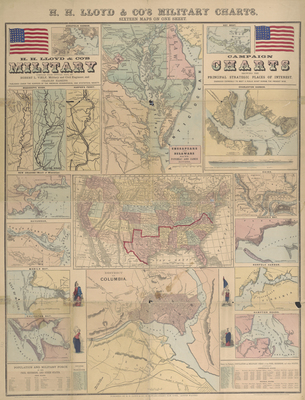
Numerous points of strategic interest appear on one large sheet published by H. H. Lloyd & Co. of New York in the first year of the American Civil War. Of the seventeen charts and maps included, only the central map, three Mississippi River sections at upper left, and Galveston Bay chart at lower left relate to the transMississippi West – an indication of the nation’s primary areas of focus during this period. The charts were compiled by Egbert Viele, who had an interesting military and civilian career both before, during, and after the war, serving variously as an Army lieutenant from1847-1853, then as a civil and military engineer, State Engineer of New Jersey from 1855, brigadier general of U.S. Volunteers from 1861-1863, then civil engineer again, chief engineer with a railroad, commissioner of parks for New York City, and U.S. Representative from New York from 1885-1887. It is important to note that another firm actively publishing Civil War-related maps at this time was James T. Lloyd, also of New York, who complained that H. H. Lloyd’s maps were easily confused with, but of inferior quality to, his own.
Archival Date
1861
Location
73/2
Collection Name
Cartographic Connections
Collection Number
400022
Publisher
University of Texas at Arlington Libraries
Original Format
Map
File Format
JPG
Rights
Any use of content downloaded or printed from this site is limited to non-commercial personal or educational use, including fair use as directed by U.S. copyright laws. For more information or for reproduction requests, please contact Special Collections
Subjects
United States; Washington D.C; Delaware and Chesapeake Bay; Civil War
Item Type
image
Names
Viele, Egbert L. (1824-1902)
Subjects
United States; Washington D.C; Delaware and Chesapeake Bay; Civil War