


Preview
Identifier
20157080
Description
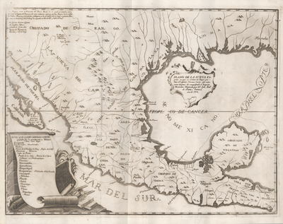
Mexico City Archbishop Francisco Antonio de Lorenzana (1722-1804), scientist and scholar Antonio Alzate y Ramirez (1739-1799), and engraver Juan Antonio Navarro (1742-ca.1809) worked in Mexico City to produce this map for a history of New Spain by the Archbishop. Working with Alzate’s 1768 map of New Spain and texts of Cortes’ second, third, and fourth letters, along with Lorenzana’s commentaries and research, they traced Cortes’ route of conquest past the island of Cozumel, around the Yucatan peninsula, to the Rio Grijalva, to Veracruz, and on to the City of Mexico. The road from Veracruz to Mexico City, long used by the Indians before Cortes, apparently became the foundation for Mexico’s National Road. Many subsequent English and French writers used Lorenzana’s presentation of Cortes’ letters as primary sources for their own histories.
Archival Date
1770
Location
18/7
Collection Name
Cartographic Connections
Collection Number
89-678
Publisher
University of Texas at Arlington Libraries
Original Format
Map
File Format
JPG
Rights
Any use of content downloaded or printed from this site is limited to non-commercial personal or educational use, including fair use as directed by U.S. copyright laws. For more information or for reproduction requests, please contact Special Collections
Subjects
Mexico; New Spain; Louisiana
Item Type
image
Names
Alzate y Ramirez, Antonio de (1737-1799)
Subjects
Mexico; New Spain; Louisiana