


Alternative Title
Barbarie
Preview
Identifier
20086374
Description
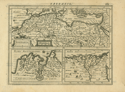
"Barbaria" map from a French-language edition of the Mercator-Hondius-Janssonius line of atlases encompasses North Africa and the famed Barbary coast of the Mediterranean as well as Syria and parts of "Natolia" (Asia Minor or Turkey), southern Italy (including Sicily) and southern Spain. It includes areas labeled "Biledulgerid", "Zanhaga", "Garamantes","Borno", "Gagoa", "Barcha", "Fez", "Numid" (Numidia) and "Maroco" (Morocco). Two large inset maps at bottom: "Carthaginensis Sinus" (Gulf of Carthage) with the city of Tunis showing fortifications and the Roman-built "Carthaginian" (Zhagouan) aqueduct; and a map "Aegyptus" (Egypt) showing the Nile Delta. Single paged, double sided. Uncolored. Full text (in French) on reverse side. 14 cm. x 19 cm. [Gift of Dr. Jack Franke]
Archival Date
1623
Collection Name
Maps of Africa
Collection Number
Acc. 2019-291
Language
French
Original Format
Maps
File Format
JPG
Rights
Rights held by The University of Texas at Arlington Libraries, Special Collections. Any use of content downloaded or printed from this page is limited to non-commercial personal or educational use, including fair use as directed by U.S. copyright laws. For more information or for reproduction requests, please contact UTA Special Collections by emailing spcoref@uta.edu.
License

This work is licensed under a Creative Commons Attribution-NonCommercial 4.0 International License
Subjects
Maps; Africa; Deserts; Rivers; Mountains; Aqueducts; Carthage; Egypt; Forts & fortifications