


Preview
Identifier
20086372
Description
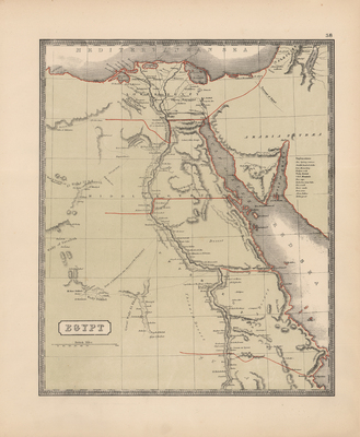
Subtly colored, detailed map of Egypt divided into the lower, middle, and upper regions. Arabia Petrae, Red Sea, and Nile Delta included. Landforms, with names of valleys labeled. Title of map and scale in British miles are located in lower left. Hachures in between landmass and coasts are depicted, with red lines indicating routes from coasts into the mainland. Explanations of simple Arabic terms translated into English are included in a word bank, located within right side of map. Page is part of atlas collection series, including maps of West and East Africa. Single-paged, single-sided, vertical map. 34 cm. x 28 cm. [Gift of Dr. Jack Franke]
Archival Date
1863
Collection Name
Maps of Africa
Collection Number
Acc. 2019-391
Language
English
Original Format
Maps
File Format
JPG
Rights
Rights held by The University of Texas at Arlington Libraries, Special Collections. Any use of content downloaded or printed from this page is limited to non-commercial personal or educational use, including fair use as directed by U.S. copyright laws. For more information or for reproduction requests, please contact UTA Special Collections by emailing spcoref@uta.edu.
License

This work is licensed under a Creative Commons Attribution-NonCommercial 4.0 International License
Subjects
Maps; Africa; Egypt; Red Sea; Deserts; Translations