


Preview
Identifier
20086342
Description
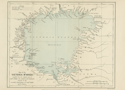
Rare map of the Lake Victoria area, from the original edition of the Journal of the Royal Geographical Society. The lake was first sighted by a European in 1858 when the explorer John Hanning Speke reached its southern shore while on his journey with Richard Francis Burton to explore central Africa and locate the Great Lakes. Believing he had found the source of the Nile on seeing this “vast expanse of open water” for the first time, Speke named the lake after Queen Victoria. Uncolored surrounding regions of lake, lightly blue colored lake. 19 cm. x 24 cm. [Gift of Dr. Jack Franke]
Archival Date
1876
Collection Name
Maps of Africa
Collection Number
Acc. 2019-360
Language
English
Original Format
Maps
File Format
JPG
Rights
Rights held by The University of Texas at Arlington Libraries, Special Collections. Any use of content downloaded or printed from this page is limited to non-commercial personal or educational use, including fair use as directed by U.S. copyright laws. For more information or for reproduction requests, please contact UTA Special Collections by emailing spcoref@uta.edu.
License

This work is licensed under a Creative Commons Attribution-NonCommercial 4.0 International License
Subjects
Maps; Africa; Lakes