


Preview
Identifier
20086477
Description
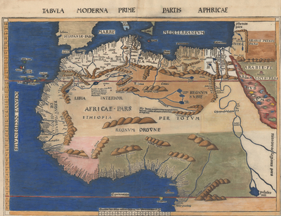
The German cartographer known world-wide as the man who first named America on a 1507 world map, Martin Waldseemüller (ca.1475-1518), created this landmark map of West Africa and the rest of the maps in the edition of Ptolemy’s geography printed in Strasbourg by Johann Schott in 1513.1 Largely based upon sailors’ accounts and portolan coastal charts, this “Modern Map of the First Part of Africa” from Waldseemüller’s supplement section -- unlike his Ptolemaic-style map of Africa he also placed in the geography -- shows both the Mediterranean and Atlantic African coastlines with considerable accuracy extending detailed place names beyond the Bight of Benin. Not surprisingly, given Europeans’ lengthier contact and greater familiarity, there is some good detail in the North African interior. Unlike many subsequent cartographers, Waldseemüller recognized the paucity of accurate information for much of the rest of the interior and left it largely blank, only adding some speculative mountain ranges represented by formations looking much like twisted dough. The rich coloring on this map includes blue lapis lazuli. [Gift of Jack Franke]
Archival Date
1513
Location
115/1
Collection Name
Maps of Africa
Collection Number
2019-150
Publisher
University of Texas at Arlington Libraries
Original Format
Map
File Format
JPG
Rights
Any use of content downloaded or printed from this site is limited to non-commercial personal or educational use, including fair use as directed by U.S. copyright laws. For more information or for reproduction requests, please contact Special Collections
Item Type
image
Names
Waldseemüller, Martin (1470-1520)
Subjects
Africa