


Preview
Identifier
20086393a
Description
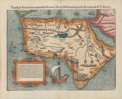
In 1540, Sebastian Münster assembled not only twenty-seven original Ptolemaic maps but also twenty-one new maps for his edition of Ptolemy’s Geographia. His work included for the first time separate maps of all the continents. Münster’s new map of Africa, seen here in a 1558 Italian posthumous edition, was one of the earliest maps to focus upon and show Africa in its entirety. One of the most unusual features was the vignette depiction of the one-eyed “Monoculi” or Cyclopes near the Bight of Benin, derived from ancient and medieval sources. In addition to an elephant and parrots in trees, Münster included cities or towns, mountains, rivers, lakes, kingdoms (denoted by royal crowns and scepters), and a medieval ship – a single-masted cog – off the western coast of southern Africa. Near the confluence of several rivers leading from the Mountains of the Moon, other mountain chains, and lakes to the Nile he added “Hamarich,” described as the seat of Prester John, the long sought-for mythical Christian King. Like Sylvano’s map (cat. no. 21), the text for the maps in Münster’s works were printed with moveable metal type in various fonts and sizes attached to carved-out portions of the woodblocks. [Gift of Jack Franke]
Archival Date
1558
Location
115/1
Collection Name
Maps of Africa
Collection Number
2019-181
Publisher
University of Texas at Arlington Libraries
Original Format
Map
File Format
JPG
Rights
Any use of content downloaded or printed from this site is limited to non-commercial personal or educational use, including fair use as directed by U.S. copyright laws. For more information or for reproduction requests, please contact Special Collections
Item Type
image
Names
Münster, Sebastian (1488-1552)
Subjects
Africa