


Preview
Identifier
20086471
Description
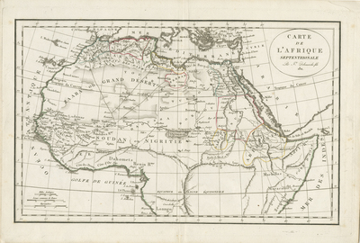
Uncolored map of northern Africa, with the Sahara, referred to as, "Zaara ou Grand Desert." Title cartouche located in upper right, with date "1811." Surrounding border of map includes scale. Scale key measured in Arabic and medieval French units in lower left corner. Hachures depicted off coast(s). Tribes, landforms, waterways, and travel routes noted throughout. Neighboring regions of Arabia, Syria,and southern Mediterranean generally depicted, including surrounding islands of Africa. Regions within northern Africa delineated by different colored outlines. Double-paged, single-sided, horizontal map bound at centrefold on verso. 29 cm. x 44 cm. [Gift of Dr. Jack Franke]
Archival Date
1811
Collection Name
Maps of Africa
Collection Number
Acc. 2019-351
Language
French
Original Format
Maps
File Format
JPG
Rights
Rights held by The University of Texas at Arlington Libraries, Special Collections. Any use of content downloaded or printed from this page is limited to non-commercial personal or educational use, including fair use as directed by U.S. copyright laws. For more information or for reproduction requests, please contact UTA Special Collections by emailing spcoref@uta.edu.
License

This work is licensed under a Creative Commons Attribution-NonCommercial 4.0 International License
Subjects
Maps; Africa; Cartouches (Graphic); Deserts; Mediterranean Sea; Waterways