


Preview
Identifier
20086436
Description
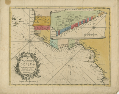
Colored map of western African coast, including north of Cape Blanco and the Senegal River, moving southwards past Sierra Leone, the Grain Coast, the Ivory Coast, the Gold Coast, Calabar, into Angola. Inset of Gold Coast provided within top right region of map. Within inset, small-scale felur-de-lis motif is located above the provided compass rose. Towns, settlements, rivers, roads, and forests are located with prevailing seasonal trade winds depicted (using arrows). Decorative title cartouche located in bottom left corner. Map is reference for the African slave trade during the mid-18th century. Many coastal cities along the coast depicted are slave ports. Map generally denotes which countries/companies control each fort (without key), occasionally providing short history/context within the slave trade. Border surrounding map includes scale. Scale key located within Atlantic Ocean at bottom center. Regions delineated by various shaded colors (without map key). Locale of various tribes noted. Hachures depicted off coast(s). Publisher information located below title cartouche, in bottom left corner. Single-paged, single-sided, horizontal map on laid paper. Without centrefold or binding on verso. 28 cm. x 35 cm. [Gift of Dr. Jack Franke]
Archival Date
1750
Collection Name
Maps of Africa
Collection Number
Acc. 2019-310
Language
English
Original Format
Maps
File Format
JPG
Rights
Rights held by The University of Texas at Arlington Libraries, Special Collections. Any use of content downloaded or printed from this page is limited to non-commercial personal or educational use, including fair use as directed by U.S. copyright laws. For more information or for reproduction requests, please contact UTA Special Collections by emailing spcoref@uta.edu.
License

This work is licensed under a Creative Commons Attribution-NonCommercial 4.0 International License
Subjects
Maps; Africa; Capes (Coastal); Coastlines; Oceans; Slave trade; Waterways; Cartouches (Graphic)