


Preview
Identifier
20086434
Description
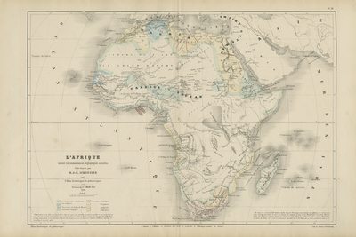
Titled: "Africa following the current geographical knowledge." This old and authentic map represents the continent of Africa. Note the large poorly charted areas and errors. The most egregious is this famous Lake "Oukérévé" or Lake Victoria. Jean-Henri Schnitzler, born in Strasbourg in 1802, was a great Alsatian historian and keen on statistics. Professor in Russia for nearly 5 years, he knew this area very well and was the author of numerous books on this Empire. His maps testify to his love of history and statistics: they include a large number of mostly historical information, but are simple and easy to read. Verso is blank. 37 cm. x 56 cm. [Gift of Dr. Jack Franke]
Archival Date
1860
Collection Name
Maps of Africa
Collection Number
Acc. 2019-375
Language
French
Original Format
Maps
File Format
JPG
Rights
Rights held by The University of Texas at Arlington Libraries, Special Collections. Any use of content downloaded or printed from this page is limited to non-commercial personal or educational use, including fair use as directed by U.S. copyright laws. For more information or for reproduction requests, please contact UTA Special Collections by emailing spcoref@uta.edu.
License

This work is licensed under a Creative Commons Attribution-NonCommercial 4.0 International License
Subjects
Maps; Africa; Island of Gorée; Islands; Mountains; Lakes; Great lakes (Africa)