


Preview
Identifier
20086420
Description
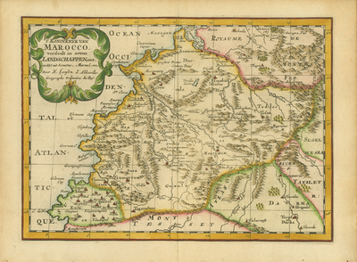
Map of the Kingdom of Morocco featuring mountains, rivers and important cities. The coastline at left stretches from the "Royaume de Fez" (Kingdom of Fez) in the north to the region of "Sus" (Souss-Massa) in the south. The city of "Marochum" (Marrakesh) lies roughly in the map's center. The map is topped with a delicate title cartouche at left, noting that the map was "getrokke[n] uit Sanutus, Marmol, enz." (drawn from Sanuto, Marmol, etc.). This refers to maps created by the Venetian geographer Livio Sanuto and his brother, the engraver Giulio Sanuto as well as descriptions by the Andalusian geographer and historian Luis del Marmol Carvajal. This map appeared in "Algemeene Weereld-Beschryving, nae de Rechte Verdeeling der Landschappen, Plaetsen, Zeeën, Rivieren, &c. Geographisch, Politisch, Historisch, Chronologisch en Genealogisch," a Dutch edition of A. Phérotée de la Croix's "Nouvelle Methode Pour Apprendre Facilement la Geographie Universelle," which first appeared in 1690. The Dutch edition was published by Francois Halma and included 98 maps and views. Halma acquired many of the plates for "Algemeene Weereld-Beschryving..." from Joannes Ribbius, who had enlisted the services of engraver Antoine de Winter to make copies of the maps in Nicolas Sanson's quarto atlases of the four continents. De Winter made very few geographical changes and maintained the attribution to Sanson on the newly engraved plates. Halma supplemented the Sanson maps with about a dozen new maps engraved in the same style as Sanson's, without any attribution on the maps, as well as 23 panoramic views of famous cities around the world. Colored, horizontal map. Double-paged, single-sided bound at centrefold. 19 cm. x 26 cm. [Gift of Dr. Jack Franke]
Archival Date
1705
Collection Name
Maps of Africa
Collection Number
Acc. 2019-275
Language
Dutch
Original Format
Maps
File Format
JPG
Rights
Rights held by The University of Texas at Arlington Libraries, Special Collections. Any use of content downloaded or printed from this page is limited to non-commercial personal or educational use, including fair use as directed by U.S. copyright laws. For more information or for reproduction requests, please contact UTA Special Collections by emailing spcoref@uta.edu.
License

This work is licensed under a Creative Commons Attribution-NonCommercial 4.0 International License
Subjects
Maps; Africa; Morocco; Mountains; Rivers; Cartouches (Graphic)