


Preview
Identifier
metapth251708
Description
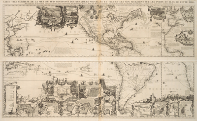
Châtelain’s highly decorative historical and geographical map of the “New World” embodies the European concept of the cabinet of curiosities, wherein encyclopedic collections of objects were strewn together in an effort to impress, educate, and entertain viewers. Although the general composition is original, many of the pictorial vignettes were directly copied from other maps and travel accounts by the map’s engraver, Bernard Picart. The map’s illustrations are thus a compilation of New World visual imagery just as the map itself is a compilation of other maps, surveys, and descriptions. For examples, the busy anthropomorphic beavers before Niagara Falls and the scenes of cod fishing on the Grand Banks off Newfoundland that illustrate some of the lucrative products found in North America had already been copied over and over, having originally appeared on a wall map with engraved illustrations by Nicolas Guérard for French cartographer Nicolas de Fer. The image of Niagara Falls itself first appeared in the 1697 account written by the first European eyewitness to the natural landmark, Louis Hennepin. The portrait tondos of European explorers add historical interest and context. Some of the ethnographic depictions of native ceremonies and a bizarrely shaped Aztec pyramid demonstrate that illustrators had as much difficulty as cartographers in authenticating their sources. Topographically, the map offers only a modest amount of information and was in its time far behind more advanced and innovative French maps of the period by Guillaume Delisle. In the North American Southwest, for example, California is an island, the Mississippi is dangerously close to Texas, and the “Riviere du Nord ou [or] Brave” lacks the Big Bend but at least flows into the Gulf of Mexico and not into the “Mer de Californie” as on some earlier maps. [Gift of Virginia Garrett]
Archival Date
ca. 1720
Location
139/1
Collection Name
Cartographic Connections
Collection Number
00877a-b
Publisher
University of Texas at Arlington Libraries
Original Format
Map
File Format
JPG
Rights
Any use of content downloaded or printed from this site is limited to non-commercial personal or educational use, including fair use as directed by U.S. copyright laws. For more information or for reproduction requests, please contact Special Collections
Subjects
South America; North America; Africa
Item Type
image
Names
Châelain, Henri Abraham (1684-1743)
Subjects
South America; North America; Africa