


Preview
Identifier
metapth251694
Description
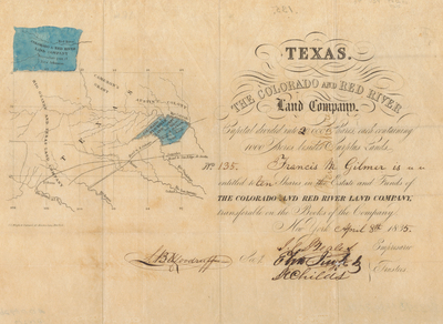
The Colorado and Red River Land Company of New York and Texas issued this map and stock certificate relating to its vast lands in Texas. The company had tenuous claims to the lands through the Mexican government’s grants to the English-born empresario Dr. John Charles Beales (1804-1878), whose signature appears on the stock certificate. The company’s lands from Wilson & Exeter’s Grant appear in pink at the upper left of the larger map. The numerous notations about the quality of the land derive from the 1827 survey by Alexander LeGrand, who was employed by Wilson and Exeter. Not surprisingly, the only comment about the Native Americans already there is in fine print (“Bought 191 B[uffalo] skins of the Comanches”) and seems to imply they would also be friendly to settlers and land speculators (!). Also in pink in the center of this map are the company’s lands from Milam’s Grant between the Colorado and Guadalupe Rivers. Just west are lands acquired by Beales from the former empresario land grant of Lucius Woodbury and sold to the Rio Grand & Texas Land Company. Just south of these lands, between the Nueces and the Rio Grande, is Beale’s [sic., Beales’] River Grant. This is outlined in pink along with the rest of the state of Coahuila. Along Las Moras Creek within Beales’ River Grant is the town of Dolores, named for Beales’ wife. [Gift of Virginia Garrett]
Archival Date
1835
Location
142/7
Collection Name
Cartographic Connections
Collection Number
00692b
Publisher
University of Texas at Arlington Libraries
Original Format
Map
File Format
JPG
Rights
Any use of content downloaded or printed from this site is limited to non-commercial personal or educational use, including fair use as directed by U.S. copyright laws. For more information or for reproduction requests, please contact Special Collections
Subjects
Texas
Item Type
image
Names
Colorado and Red River Land Company
Subjects
Texas