


Preview
Identifier
metapth251677
Description
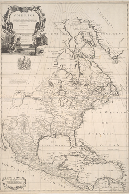
By here focusing largely upon eastern North America, British map producers Senex, Price, and Maxwell avoided the cartographic problems still associated in the early 18th -century with the depiction of California as an island and the mysterious Northwest Coast which was still largely unknown to Europeans. They copied and translated French mapmaker Delisle’s 1703 Carte du Canada ou de la Nouvelle France for the northern part of their map and Delisle’s 1703 Carte du Mexique et de la Floride for the southern portion. Surprisingly, the Englishmen even copied the Frenchmen’s dotted-line political boundaries, but not surprisingly, they did not credit or mention Delisle. Senex did add a different cartouche. Around 1717 George Whilldey and his engraver H. Terrasson, in turn, copied Senex, Price, and Maxwell’s map for Whillldey’s Atlas of the World. [Gift of Virginia Garrett]
Archival Date
1710
Location
142/6
Collection Name
Cartographic Connections
Collection Number
00551
Publisher
University of Texas at Arlington Libraries
Original Format
Map
File Format
JPG
Rights
Any use of content downloaded or printed from this site is limited to non-commercial personal or educational use, including fair use as directed by U.S. copyright laws. For more information or for reproduction requests, please contact Special Collections
Subjects
Mexico; New Spain; Florida; Cuba
Item Type
image
Names
Senex, John (1678-1740)
Subjects
Mexico; New Spain; Florida; Cuba