


Preview
Identifier
metapth251674
Description
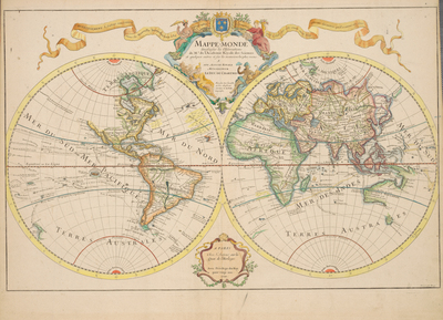
This was Del’ Isle ’s first world map. This edition is a corrected version of the 1700 map. The address notation in the platemark, “Chez l’Auteur sur le Quai de l’Horloge,” substantiates that this map was done after he moved to that location in 1707, even though it is dated “1700.” In the second edition Del’ Isle used new information to correct his representation of the Great Lakes, South America, and the Niger River in Africa. Del’ Isle is known as the first scientific geographer. He came from a family of geographers and historians. His father, Claude, was both a geographer and historian. All of his brothers became either scientists or historians. His brother, Louis Del’ Isle, went on a 1728 expedition with the Russian explorer Bering. Guillaume Del’ Isle insisted on complete documentation for his maps. He did not accept the work of other mapmakers without confirmation from other sources. At a time when mapmakers often filled blank spaces on maps with fanciful information, Del’ Isle was rather restrained. On this map, as well as his others, Del’ Isle left blank spaces to indicate a lack of documentation about these places. Of note on this map, the northwestern portion of North America is not illustrated, and there is no evidence of Antarctica. He consistently updated his map with new information. Del’ Isle used accounts from French explorers and colonizers of the Gulf of Mexico region. He also had access to accounts from survivors of La Salle’s expedition in the late 1680s. Del’ Isle became a member of the French Academy of Science in 1702. In 1718, the title “Primier Geographe du Roi” was created for him. His maps were highly respected and were used even after his death. He was one of the first to correctly illustrate the extended length of the Mediterranean. He was also one of the first to correctly represent the [Baja] California peninsula. Despite Del’ Isle’s efforts to produce highly accurate maps, this one contain some errors; for example, New Guinea is connected to Australia, and it appears that Japan is connected to the mainland to the north. This map has an elaborate decorative cartouche, and a banner across the top advertising Del’ Isle’s upcoming book, Novella Introduction à la Géographie. [Gift of Virginia Garrett]
Archival Date
1700
Location
135/1
Collection Name
Cartographic Connections
Collection Number
00467
Publisher
University of Texas at Arlington Libraries
Original Format
Map
File Format
JPG
Rights
Any use of content downloaded or printed from this site is limited to non-commercial personal or educational use, including fair use as directed by U.S. copyright laws. For more information or for reproduction requests, please contact Special Collections
Subjects
Africa; Europe; Asia; South America; North America; Australia
Item Type
image
Names
Delisle, Guillaume (1675-1726)
Subjects
Africa; Europe; Asia; South America; North America; Australia