


Preview
Identifier
metapth251670
Description
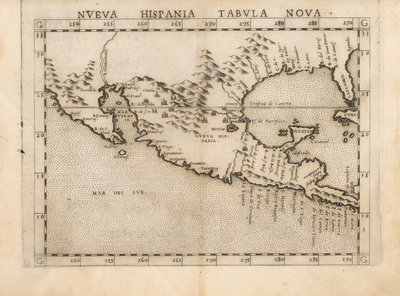
Ruscelli’s 1561 map of New Spain was an enlarged copy of fellow Venetian Giacomo Gastaldi’s 1548 map of New Spain, but with a major difference: Ruscelli’s map showed Yucatan correctly as a peninsula, not an island. Both were New World addendum maps for “modern” editions of the 2nd century Greek geographer Claudius Ptolemy’s book on geography. [Gift of Virginia Garrett]
Archival Date
1561
Location
128/12
Collection Name
Cartographic Connections
Collection Number
00384
Publisher
University of Texas at Arlington Libraries
Original Format
Map
File Format
JPG
Rights
Any use of content downloaded or printed from this site is limited to non-commercial personal or educational use, including fair use as directed by U.S. copyright laws. For more information or for reproduction requests, please contact Special Collections
Subjects
New Spain; Texas; Mexico; Florida; Cuba
Item Type
image
Names
Ruscelli, Girolamo (1518-1566)
Subjects
New Spain; Texas; Mexico; Florida; Cuba