


Preview
Identifier
metapth190545
Description
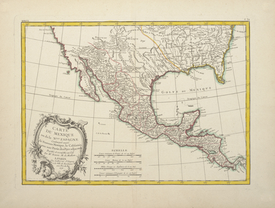
French hydrographic engineer, mathematician, and cartographer Rigobert Bonne’s 1771 map of Mexico or New Spain published by Jean Lattré or his son featured an elegant rococo-style cartouche engraved and designed by a little-known artisan named “Arrivet.” Bonne’s map shows but does not name all of a total of seventeen rivers in Texas. Missions along the left bank of the Rio Grande or “Riviere du Nord” above its junction with the Pecos (here labeled the “Riv. Salado ou Riviere des Apaches”) include St. Christophe (San Cristobal, founded in 1715), St. Paul, la Conception, and St. George.
Archival Date
1771
Location
55/5
Collection Name
Cartographic Connections
Collection Number
87-591
Publisher
University of Texas at Arlington Libraries
Original Format
Map
File Format
JPG
Rights
Any use of content downloaded or printed from this site is limited to non-commercial personal or educational use, including fair use as directed by U.S. copyright laws. For more information or for reproduction requests, please contact Special Collections
Subjects
New Mexico; California; Florida; Gulf of Mexico
Item Type
image
Names
Bonne, Rigobert (1727-1794)
Subjects
New Mexico; California; Florida; Gulf of Mexico