


Preview
Identifier
metapth231571
Description
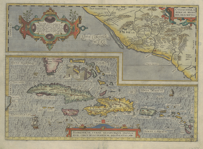
A large portion of the Caribbean, including southern Florida, the Bahamas, Cuba, Hispaniola, Jamaica, Puerto Rico, and a portion of the Lesser Antilles, appears on this hand-colored sheet from Ortelius’ world-renowned atlas that appeared in multiple editions. The other portion of the same sheet has a map showing the central part of the western coast of Mexico. In depicting the West Indies, Ortelius apparently utilized Gerhard Mercator’s 1569 world map and Diego Guttierez’ 1562 America map engraved by Hieronymous Cock. Ortelius scholar Peter Meurer also believes that Ortelius had access to a manuscript copy of Spanish Royal Cosmographer Alonso de Santa Cruz’ Islario General de Todas las Islas del Mundo, commissioned by Charles V and dating from 1560. Ortelius also drew upon cartographic details and toponyms from earlier printed maps.
Archival Date
1581
Location
54/3
Collection Name
Cartographic Connections
Collection Number
2011-287
Publisher
University of Texas at Arlington Libraries
Original Format
Map
File Format
JPG
Rights
Any use of content downloaded or printed from this site is limited to non-commercial personal or educational use, including fair use as directed by U.S. copyright laws. For more information or for reproduction requests, please contact Special Collections
Subjects
Cuba; Yucatan
Item Type
image
Names
Ortelius, Abraham (1527-1598)
Subjects
Cuba; Yucatan