


Preview
Identifier
metapth231564
Description
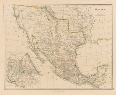
John Arrowsmith’s 1832 map of Mexico was a compilation of the latest and best sources available in London and has been called “…arguably the best map of the country published prior to the 1850s.”* It included a number of the country’s important roads for the first time on a printed map, employing double lines to refer to primary roads, single lines for secondary roads, and dotted lines for paths. Much of the information for the roads and trails came from British travelers in Mexico such as diplomat Henry George Ward (1797-1860) and Royal Navy officers R. W. H. Hardy (ca.1790-1871) and Frederick William Beechey (1796-1856). Ward, in his book Mexico in 1827 included a Map of Routes to the Principle Mining Districts in the Central States of Mexico engraved by Sidney Hall. Hardy, who wrote Travels in the Interior of Mexico in 1825, 1826, 1827 and 1828 (London: H. Colburn and R. Bentley, 1829), had arrived in Veracruz in 1825 and then traveled overland to Mexico City. From there Hardy had traveled to Mazatlan, where he took ship to explore Mexico’s Pacific and Gulf of California coasts as far as the Colorado River. He returned to Mexico City through Sonora and Chihuahua. Although Hardy did not always have the best survey instruments available for taking measurements, he had enlisted the aid of his ship’s master William Lindon. In Hardy’s book’s accompanying Map of Sonora and the Gulf of California, also engraved by Sidney Hall, Hardy had improved upon Alexander von Humboldt’s cartographic depictions of these areas. Beechey, meanwhile, had explored Mexico’s Pacific coast line, from California south, taking geodetic readings at Mazatlan and San Blas. His experiences were published in Narrative of a Voyage to the Pacific and Beering’s Strait…Performed in His Majesty’s Ship Blossom under the Command of Captain F. W. Beechey, R.N. (Philadelphia: Carey & Lea, 1832). The Arrowsmith family were generally recognized as the leading English mapmakers of the late 18th and early 19th century. John Arrowsmith (1790-1873) was the nephew and eventual successor of the company founder Aaron Arrowsmith, Sr. (1750-1823). Not surprisingly, the base for John’s map of Mexico was Aaron Sr.’s map of Mexico of 1810 which in turn had utilized Alexander von Humboldt’s great map of Mexico of 1809 and Royal Navy coastal charts. [Gift of Virginia Garrett]
Archival Date
1832
Location
135/1
Collection Name
Cartographic Connections
Collection Number
00895
Publisher
University of Texas at Arlington Libraries
Original Format
Map
File Format
JPG
Rights
Any use of content downloaded or printed from this site is limited to non-commercial personal or educational use, including fair use as directed by U.S. copyright laws. For more information or for reproduction requests, please contact Special Collections
Subjects
Mexico; United States
Item Type
image
Names
Arrowsmith, John (1790-1873)
Subjects
Mexico; United States