


Preview
Identifier
metapth231474
Description
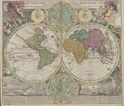
This double-hemisphere world map features insets of the celestial northern hemisphere and the celestial southern hemisphere, both of which show the mythological figures and objects of the constellations. Windheads and illustrations of a volcanic eruption, earthquake, tides, water-spouts, and a rainbow decorate the four corners of the composition. The map shows California as insular and traces the sailing routes of the explorers Magellan, Olivier van Noort, William Dampier, Abel Tasman, and Juan Gaetano. Nuremberg cartographer and map publisher Homann and his family later produced a number of celestial and selenographical (lunar) charts in conjunction with the Nuremberg astronomer and mathematician Johann Gabriel Doppelmayr (1677- 1750). Many of these charts were featured in Doppelmayr’s Atlas coelestis, which Homann’s Heirs published in 1742. [Gift of Virginia Garrett]
Archival Date
1707
Location
132/7
Collection Name
Cartographic Connections
Collection Number
00705
Publisher
University of Texas at Arlington Libraries
Original Format
Map
File Format
JPG
Rights
Any use of content downloaded or printed from this site is limited to non-commercial personal or educational use, including fair use as directed by U.S. copyright laws. For more information or for reproduction requests, please contact Special Collections
Subjects
South America; Asia; Africa; Europe; North America
Item Type
image
Names
Homann, Johann Baptist (1663-1724)
Subjects
South America; Asia; Africa; Europe; North America