


Preview
Identifier
metapth220447
Description
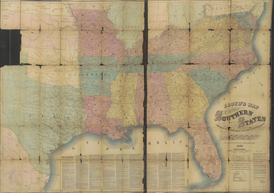
J. T. Lloyd published a gazetteer concerning railroad lines in the United States. This publication probably served as a “roadmap” for commerce and those seeking to make use of rail transport. When the Civil War broke out in 1861, Lloyd hoped to take advantage of interest in the war by publishing his reworked rail maps. Lloyd included several advertisements for others of his works related to railroads and updated war maps. One of his ads requested possible agents for this work to contact him. The map appears to be a wall map that has been folded many times. The copy in the UTA Libraries, Special Collections Division is worn, with some holes on the border. Readers not only in the United States, but also in other parts of the world, especially Europe, liked to consult maps to keep up with the events taking place during the Civil War. The map was printed in London, and the mileage legends are in Italian, French, and German. Readers could locate places on the map as news became available from the front and perhaps mark the location on the map. Military personnel on both sides lacked quality maps. This map might have provided information about the location of transportation centers, cities and small communities, the depth of coastlines and harbors as well as rivers and some forts (Vicksburg shows steamboat batteries). Other maps published during the Civil War by Lloyd included a map of Virginia which was supposedly used by Union commander General Winfield Scott in planning his campaigns. In a subsequent updated map, the cartographer claimed the map had been corrected by Captain W. Angelo Powell of the United States Topographical Engineers and used by General George McClelland. Items included in this map of public and military interest include state capitals, cities, counties, towns, forts, barracks, courthouses, and lighthouses. Along the bottom of the map is information about every major port on the southern coast, including statistics regarding the depth and width of harbors and topical information including facts about recent battles near those harbors as well as descriptions of possible navigable rivers. The map is large, two sheets, with a variety of information. On the back is a listing of many southern counties, their population, and types of soil found in the county. Some counties included information on the number of schools, churches, and libraries.
Archival Date
1862
Location
99/3
Collection Name
Cartographic Connections
Collection Number
800318a-b
Publisher
University of Texas at Arlington Libraries
Original Format
Map
File Format
JPG
Rights
Any use of content downloaded or printed from this site is limited to non-commercial personal or educational use, including fair use as directed by U.S. copyright laws. For more information or for reproduction requests, please contact Special Collections
Subjects
United States; Civil War
Item Type
image
Names
Loyd, James T.(1857-1865)
Subjects
United States; Civil War