


Preview
Identifier
metapth220334
Description
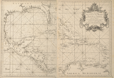
This two-sheet map of the Gulf and Caribbean, dedicated to the King of Spain Fernando VI, was one of the first maps produced by López along with his fellow Spanish student expatriate in Paris, Juan de la Cruz Cano y Olmedilla (1734- 1790). European knowledge of the coastlines of the Caribbean islands, Central America, and southern North America was extensive by the eighteenth century. Betweeen 1783 and 1786, the Gulf was resurveyed in a systematic manner by the primer piloto José de Hevia.
Archival Date
1755
Location
107/6
Collection Name
Cartographic Connections
Collection Number
2000-99a-b
Publisher
University of Texas at Arlington Libraries
Original Format
Map
File Format
JPG
Rights
Any use of content downloaded or printed from this site is limited to non-commercial personal or educational use, including fair use as directed by U.S. copyright laws. For more information or for reproduction requests, please contact Special Collections
Subjects
New Spain; Louisiana; Florida; Dominican Republic
Item Type
image
Names
Vargas Machuca, Thomas López y (1630-1702); Cruz Cano y Olmedilla, Juan de la (1734-1790)
Subjects
New Spain; Louisiana; Florida; Dominican Republic