


Preview
Identifier
metapth193723
Description
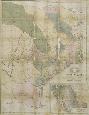
After winning their independence from Mexico in 1836, Texans claimed more extensive borders for their republic than the former Mexican province had ever administered or even claimed. This map from one of the first guides to the republic shows the lower Rio Grande as the southern and western boundary. Many new towns and counties appear for possibly the first time. The inset Map of the Rio Grande and the Country west to the Pacific, probably based upon Tanner’s maps of Mexico, suggests that Texans cast their eyes much farther than just the records of the General Land Office of the Republic. There are Lower and Upper California here, with the rivers Timpanogos and Buenaventura flowing southwest from their large lakes to the Pacific. In a poorly-understood western Texas, lack of color and a line of mountains labeled “Guadalupe Mt. Old Texas Boundary” imply the new boundary claim all the way to the upper Rio Grande. Texans would soon test, but not reduce, the limits of their border claims in the failed Santa Fe and Mier expeditions of 1841 and 1842. The influential map went through a second edition in 1845 and was also translated into German to accompany an important emigrant guide by Georg A. Scherpf, published in Augsburg in 1841.
Archival Date
1839
Location
83/3
Collection Name
Cartographic Connections
Collection Number
95-27
Publisher
University of Texas at Arlington Libraries
Original Format
Map
File Format
JPG
Rights
Any use of content downloaded or printed from this site is limited to non-commercial personal or educational use, including fair use as directed by U.S. copyright laws. For more information or for reproduction requests, please contact Special Collections
Subjects
Texas; Mexico
Item Type
image
Subjects
Texas; Mexico