


Preview
Identifier
metapth192687
Description
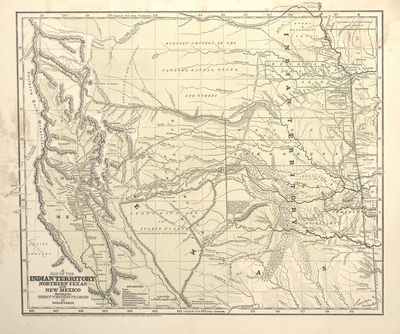
Santa Fe trader and historian Josiah Gregg’s map was arguably the best to depict the southwestern prairies in its time. It shows various routes of the Santa Fe and Chihuahua traders, including Gregg’s own treks, between and through Missouri, Arkansas, Texas, and Indian Territory. There are, for examples, Gregg’s Route to Santa Fe in 1839, Gregg’s route in 1840, and the “Route of the Santa Fe Caravans” (all variations on the Santa Fe Trail). Gregg also compiled information from other maps. For example, there is “La Jornado del Muerto” (i.e., the Journey of Death along the middle Rio Grande in New Mexico dating back to the Spanish era and earlier), the “Route of Capt. Pike,” “Capt. Pike’s Route in 1806,” the “Route of Maj. Long 1820,” the “Route of Texan Santa Fe Expedition 1841” including the split with “Route of Col. Cooke’s Division” and “Route of main division with wagons,” “Capt. Boone in 1843” (sic, a reference to Captain Nathan Boone who was part of the U.S. First Dragoon expedition in 1834), “Route of the Oregon Emigrants” (the Oregon Trail), “Military Road” between Ft. Smith and Ft. Towson, and roads between Chickasaw Depot and Ft. Smith, and from Ft. Smith to Ft. Gibson. The routes of the “Caravan from Chihuahua to Arkansas” in 1839 and back “from Arkansas to Chihuahua” in 1840 are also depicted. Often identified with Missouri physician and prominent merchant Henry C. Connelly, this “Chihuahua Expedition” was a cooperative effort between local officials and merchants in Chihuahua to open a more direct trade with Arkansas that bypassed Santa Fe. The map carefully denotes towns, settlements, pueblos, forts, trading posts, camps, springs, rivers, creeks, wooded areas such as the Cross Timbers, sandy regions including parts of the Canadian River valley, mountains and escarpments such as the “Wichita Mts” and the edges of the “Llano Estacado or Staked Plains.” The map depicts the ranges and hunting grounds of Indians such as the Comanche, Kiowa, Pawnee, Kanza, Oto, and other peoples. But it also shows lands allotted to more agriculturally settled tribes recently removed from the east such as the Seminole, Cherokee, Osage, Shawnee, Delaware, Choctaw, Chickasaw, and Waco. Even lands allotted to “Half Breeds” turn up on this map, which was printed in two colors by cerography, a new wax engraving transfer process, by the firm of Morse and Breese. The map and Gregg’s book went through multiple editions, both in English and German.
Archival Date
1844
Location
46/11
Collection Name
Cartographic Connections
Collection Number
83-551a
Publisher
University of Texas at Arlington Libraries
Original Format
Map
File Format
JPG
Rights
Any use of content downloaded or printed from this site is limited to non-commercial personal or educational use, including fair use as directed by U.S. copyright laws. For more information or for reproduction requests, please contact Special Collections
Subjects
Texas; New Mexico; Indian Territory
Item Type
image
Names
Gregg, Josiah (1806-1850)
Subjects
Texas; New Mexico; Indian Territory