


Preview
Identifier
metapth192468
Description
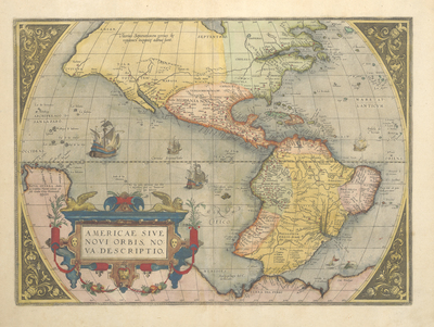
Ortelius’ first map of the Americas from the Theatrum Orbis Terrarum (or “Theatre of the World” -- what many consider to be “the first modern atlas”) has been called the “great Renaissance summation of the discovery and exploration of the New World.” The importance lies not only in the information on the map itself but also the fact that Ortelius’ atlases received wide distribution throughout Europe in numerous editions in multiple languages. Much of the information on the map came from Spanish charts, Diego Gutiérrez the elder’s map of 1562 published by Hieronymus Cock in Antwerp (the first wall map of the Americas), and Ortelius’ friend Gerard Mercator’s world map of 1569 (also a large wall map). An accurate depiction of the Gulf of Mexico shows the “R. de S. Spirito” (Mississippi River) correctly flowing into it. Just northwest of this river appears the word “Capaschi” which perhaps refers to the Caddos or their allies encountered by Luis de Moscoso. Along what became the Texas coast may be seen a “R[io]. de Gigantes” (River of Giants), the latter referring to Pineda’s description of eightfoot-tall Indians, perhaps the Karankawas, and a C[abo]. Bravo (Cape Bravo), possibly referring to a feature near the mouth of what became the Rio Grande. Just to the south is the mouth of the Panuco River where Pineda’s ships sheltered. In the interior of what became Texas appear the “Terlichichi Mechi,” a name probably related to the derisive Nahua term for the nomadic and semi-nomadic Chichimecas, roughly meaning “barbarians.” The rivers of the area appear to flow generally southeast; however, a river in what soon became known as New Mexico -- the “Tiguas rio” (possibly a confusion of the Rio Grande of New Mexico with the Colorado River of the west) -- flows toward the Gulf of California, here called “Mar Vermejo” (Vermillion Sea). One of the most distinctive features of this early Ortelius map of the Americas is the bulge on the southwestern coast of South America (derived from Mercator’s 1569 wall map). Ortelius would soon remove this misconception in a later edition. [Gift of Virginia Garrett]
Archival Date
1570
Location
24/4
Collection Name
Cartographic Connections
Collection Number
220022
Publisher
University of Texas at Arlington Libraries
Original Format
Map
File Format
JPG
Rights
Any use of content downloaded or printed from this site is limited to non-commercial personal or educational use, including fair use as directed by U.S. copyright laws. For more information or for reproduction requests, please contact Special Collections
Subjects
New Spain; South America; America; Cuba
Item Type
image
Names
Ortelius, Abraham (1527-1598)
Subjects
New Spain; South America; America; Cuba