


Preview
Identifier
20157068a-b
Description
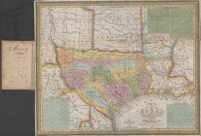
Texas was still part of the Mexican state of Coahuila and Texas in 1835 when Young and Mitchell began this popular pocket map, primarily intended as an aid to colonists and prospective Anglo immigrants from the United States. The map copied many of the features of the more famous map first issued in 1830 by Anglo-colonizer Stephen F. Austin and cartographer Henry S. Tanner. Like the Austin-Tanner map, the Young-Mitchell map was issued in many editions. It includes the notations “Droves of Wild Cattle & Horses,” “Immense Level Prairies,” “Large Herds of Buffalo,” and it indicates locations for various Indian tribes and Indian villages, rivers (including the Nueces as the southern boundary), creeks, hills, and other towns and villages. Unlike Austin’s map, however, it also shows neighboring Louisiana, Indian Territory, “Santa Fe formerly New Mexico,” and portions of Arkansas and Mississippi – apparently as a frame of reference for would-be immigrants. Inset texts promote Texas’ resources and describe the empresario system of land grants, Texas’ rivers and Texas itself as “peculiarly interesting” to the people of the United States “from its immediate contiguity, and from the circumstance of Anglo Americans forming the principle portion of its rapidly increasing population.” The text notes that a political movement to separate from Coahuila was afoot and that the shared legislature in 1834 had already approved freedom of religion and an Anglo-American-style legal system. [Gift of Kitene Kading]
Archival Date
1836
Location
52/6
Collection Name
Cartographic Connections
Collection Number
91-389
Publisher
University of Texas at Arlington Libraries
Original Format
Map
File Format
JPG
Rights
Any use of content downloaded or printed from this site is limited to non-commercial personal or educational use, including fair use as directed by U.S. copyright laws. For more information or for reproduction requests, please contact Special Collections
Subjects
Texas
Subjects
Texas