


Preview
Identifier
metapth41381
Description
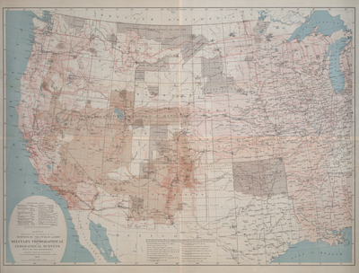
This chromolithograph represents an attempt at a cartographic summary of systematic mapping activities in the American West up to the time of the creation of the U.S. Geological Survey in 1879. The map was prepared under the direction of the U.S. Army’s George M. Wheeler, who himself had directed one of the great projects himself – the “Geographical Surveys West of the 100th Meridian.” His was a military-sponsored effort to create a large-scale official topographic map of the area in hundreds of individual sheets based upon systematic surveys. Ninety-five grids west of the meridian forming the eastern border of the Texas panhandle represent Wheeler’s proposed, but only partially complete, survey. The red grid of six-mile-square townships represents the progress of the public land surveys of the General Land Office and therefore suggests the extent of real estate development at the time. The systematic Geological Surveys of the Fortieth Parallel under Clarence King are also noted, but the surveys of Hayden and Powell are not. In 1879 Congress voted to terminate funding for Wheeler’s, Hayden’s, and Powell’s surveys, while King’s work had been completed the year before. The termination of Wheeler’s work was controversial since some insisted that, had it continued, it would have been quite adequate for the demands of its time.
Archival Date
1879
Location
102/1
Collection Name
Cartographic Connections
Collection Number
96-290
Publisher
University of Texas at Arlington Libraries
Original Format
Map
File Format
JPG
Rights
Any use of content downloaded or printed from this site is limited to non-commercial personal or educational use, including fair use as directed by U.S. copyright laws. For more information or for reproduction requests, please contact Special Collections
Subjects
United States
Item Type
image
Names
Wheeler, George M. (1842-1905)
Subjects
United States