


Preview
Identifier
metapth298830
Description
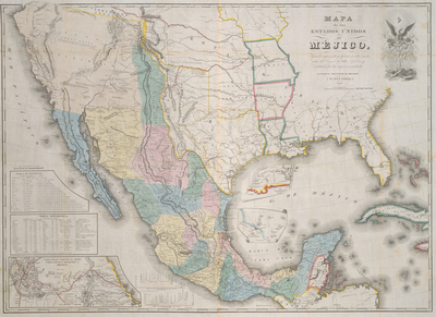
Recognizing the growing interest in Texas following its annexation by the United States and the ongoing tensions with Mexico in 1845, New York publisher John Disturnell (1801-1877) bought the copper plates of the 1828 map of Mexico by White, Gallaher and White and reissued it beginning the next year with his own name on it. This 1847 edition, while actually the 7th edition, was the first of seven variants that year. The variations were so minor that negotiators were probably not aware that the “7th edition” from 1847 was attached to the U.S. treaty, while the “12th edition” bearing the same year was attached to the Mexican copy. One of the most glaring errors of Disturnell’s maps and their predecessors was the distortion of the location of El Paso del Norte (today’s Juarez, Mexico). The maps show it miles north and east of its actual location, and, thus by the treaty, the boundary would run miles north of what the U.S. had thought they had agreed upon. The two countries appointed a joint boundary commission that spent the next several years properly surveying the boundary lines, during which time they corrected the errors
Archival Date
1847
Location
102/10
Collection Name
Cartographic Connections
Collection Number
310048
Publisher
University of Texas at Arlington Libraries
Original Format
Map
File Format
JPG
Rights
Any use of content downloaded or printed from this site is limited to non-commercial personal or educational use, including fair use as directed by U.S. copyright laws. For more information or for reproduction requests, please contact Special Collections
Subjects
Texas; Mexico; California
Item Type
image
Names
Disturnell, John (1801-1877)
Subjects
Texas; Mexico; California