


Preview
Identifier
metapth298825
Description
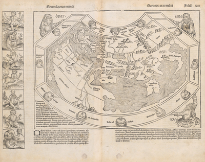
This page from the celebrated “Nuremberg Chronicle” of 1493 depicts the world as commonly known to most educated Europeans before the discoveries of Columbus in the Americas were understood. The woodcut map reflects a combination of ancient Greco-Roman geographical understanding with symbolism based upon JudaeoChristian traditions. The shape of the map derives from textual descriptions of the world passed down through the Middle Ages from Ptolemy’s second-century Geography without great attention to detail. Twelve windheads surround the map, the outline of which is held up by three figures depicting the sons of Noah: Shem, Ham, and Japheth, from whom all peoples in the three known continents of Asia, Africa, and Europe were believed to descend. To the left of the map are seven depictions of monstrous or freakish characters situated to suggest that such creatures inhabit the edges of the world. A further fourteen of these mythic monstrous figures, inspired by ancient sources such as Pliny, Pomponius Mela, Solinus, and Herodotus’ Fables appear on the reverse side of the page.
Archival Date
1493
Location
113/1
Collection Name
Cartographic Connections
Collection Number
220004
Publisher
University of Texas at Arlington Libraries
Original Format
Map
File Format
JPG
Rights
Any use of content downloaded or printed from this site is limited to non-commercial personal or educational use, including fair use as directed by U.S. copyright laws. For more information or for reproduction requests, please contact Special Collections
Subjects
World; Asia; Africa; Europe
Item Type
image
Names
Schedel, Hartmann (1440-1514)
Subjects
World; Asia; Africa; Europe