


Preview
Identifier
metapth298306
Description
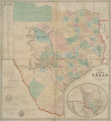
Texas land agent, promoter, and colonizer Jacob DeCordova (1808-1868) commissioned Texas General Land Office cartographer Robert Creuzbauer (ca.1823- after 1910) to produce this map “from records of the General Land Office…” Among the trails it delineates are three important roads between San Antonio and Presdio del Rio on the Rio Grande: the “Upper” road, the “Lower or old” road, and, to the north of them both, “Woll[‘]s Road.” The latter referred to a smuggler’s trail entering San Antonio from the hills to the west of the town used by the French-born Mexican General Adrian Woll for his surprise raid on San Antonio in 1842. (Although Woll’s men only held the town for a week, they managed to slip back into Mexico with a number of Texan prisoners.) The small inset map includes the “Caravan Route from Arkansas 1840” to Paso del Norte – a reference to the return journey of a group of Mexican traders from Chihuahua who had come up the trail the year before. The inset also shows “Gen[era]l. Kearny’s Route [in] 1846” from Missouri to Santa Fe. DeCordova’s map was a masterpiece of promotion because it updated and further refined the basic composition of Richard S. Hunt and Jesse F. Randel’s 1845 map of Texas. Like Hunt & Randel’s map, the DeCordova/Creuzbauer production has facsimile signature endorsements and an inset showing Texas’ grandiose boundary claims. However, while Hunt & Randel’s has endorsements from the Texas Secretary of State, the editor of the Houston Telegraph, the Texas General Land Commissioner, and the Texas Consul General in New York, DeCordova obtained the facsimile endorsements of similar officials plus the arguably more famous Texas pioneer heroes, soldiers, and politicians Thomas J. Rusk, Sam Houston, and John C. Hays. Reportedly Sam Houston even praised the map on the floor of the U.S. Senate, calling it “the most correct and authentic map of Texas ever compiled.” DeCordova issued revised editions until 1861. [Gift of Virgina Garrett]
Archival Date
1849
Location
140/9
Collection Name
Cartographic Connections
Collection Number
00588
Publisher
University of Texas at Arlington Libraries
Original Format
Map
File Format
JPG
Rights
Any use of content downloaded or printed from this site is limited to non-commercial personal or educational use, including fair use as directed by U.S. copyright laws. For more information or for reproduction requests, please contact Special Collections
Subjects
Texas
Item Type
image
Names
Creuzbauer, Robert
Subjects
Texas