


Preview
Identifier
metapth298281
Description
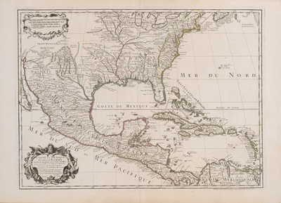
Delisle’s 1703 map, seen in this virtually identical 1745 reissue by his son-in-law and successor Philippe Buache, was one of the first printed maps to give a good general idea of the course of the Mississippi River and some of its major tributaries. It included information from d’Iberville’s and La Salle’s explorations, Spanish texts, Coronelli’s (Penalosa’s) New Mexico, Bisente’s chart, and Sigüenza’s map. East of the Missisippi Delisle’s Apalachicola River flows almost due south from a large lake in present Tennessee based on information from seventeenth-century Englishman Richard Bristock or Brigstock. Delisle attempted to include locations of many Native American tribes, spelling their names in phoenetic French: Alibamous, Chaktas, Chicachas, Caddodaquio, Choumans, and others. Delisle’s map was widely copied throughout Europe. [Gift of Virgina Garrett]
Archival Date
1703
Location
141/3
Collection Name
Cartographic Connections
Collection Number
00468
Publisher
University of Texas at Arlington Libraries
Original Format
Map
File Format
JPG
Rights
Any use of content downloaded or printed from this site is limited to non-commercial personal or educational use, including fair use as directed by U.S. copyright laws. For more information or for reproduction requests, please contact Special Collections
Subjects
Mexico; New France; New Spain; Canada; Cuba
Item Type
image
Names
Delisle, Guillaume (1675-1726)
Subjects
Mexico; New France; New Spain; Canada; Cuba